
LiDAR Mapping for Timberland Owners Planning a Future Homesite
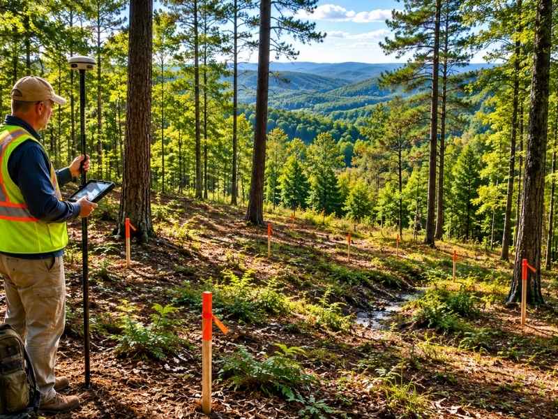
LiDAR mapping is changing how timberland owners plan for a future home. A wooded tract can look great from the road and still hide serious problems under the trees. Slopes, drainage channels, and wet spots that aren’t obvious on the ground show up clearly when accurate elevation data is collected from above. For owners who want to pick a good homesite before spending money on clearing or grading, that information makes a big difference.
Why Walking Wooded Land Gives an Incomplete Picture
Most timberland owners have walked their property many times. They know the general feel of the land. But walking a wooded tract has real limits when it comes to picking a homesite.
Dense brush makes it hard to judge slope. A hillside that feels gradual on foot can turn out to be much steeper once the trees are gone. Low spots that look dry during a summer walk may hold water for months after heavy rain. Creek channels hidden by leaves and brush can run surprisingly close to areas that otherwise look flat and open.
These things matter because they affect where a home can safely go. A site that looks perfect during a dry fall visit can show drainage problems or unstable ground the moment clearing begins. By then, the owner has already committed to a spot that may need expensive fixes.
LiDAR data removes that uncertainty by showing accurate elevation across the entire tract before any trees come down.
How LiDAR Data Helps Compare Multiple Candidate Sites
One of the most useful things LiDAR data can do for a timberland owner is help compare several possible building spots on the same tract before choosing one.
On a 50-acre or 100-acre wooded property, there may be three or four spots that feel like good options. Walking each one and comparing them by memory is imprecise. A LiDAR elevation model lets an owner and their surveyor or engineer look at each candidate site using real terrain data.
That comparison can cover several things at once:
- Slope. Which sites are naturally level enough for a house without major grading?
- Drainage. Which sites shed water naturally, and which ones sit where water collects?
- Views. Which elevations offer the best sight lines across the property?
- Road access. Which sites allow the shortest and least expensive driveway?
Comparing those factors using actual data leads to a much better decision than relying on impressions from a walk. It also reduces the chance of picking a spot that looks good on the ground but creates big problems during construction.
What LiDAR Reveals About Seasonal Water Movement
Water behavior on a wooded tract changes a lot between wet and dry seasons. An owner who visits in late summer may have no idea where water flows or where it pools after rain. Those patterns are invisible from the ground unless you happen to visit right after a storm.
LiDAR elevation data makes seasonal water behavior visible any time of year. By studying the shape of the land, engineers and planners can find low points where water collects, flow channels that carry runoff across the property, and areas that stay wet long after other spots dry out.
This matters when choosing a homesite. A site that sits between two ridges may collect runoff from many surrounding acres. A spot that looks flat may slope just enough to push water toward a future crawl space or basement. A driveway crossing that looks simple may sit over a seasonal channel that flows hard enough in winter to wash out a gravel road.
Knowing where water moves before choosing a homesite helps avoid building in the wrong place.
How Driveway Length and Grade Affect Homesite Cost
The cost of reaching a homesite on a wooded tract is easy to underestimate. A house sitting a quarter mile from the road on sloped land needs a driveway that climbs, curves, and crosses whatever obstacles the terrain puts in the way. That adds up fast.
LiDAR data helps check driveway options before any clearing starts. Grade is one of the key factors. Most residential driveways need to stay below a certain slope to be safe and usable in wet or icy weather. LiDAR elevation data lets a surveyor or engineer trace possible driveway routes and calculate the grade along each one.
A route that looks direct on a map might have a steep section that would require major earthwork to fix. A slightly longer route around the slope might stay within safe grade limits and cost far less to build. Without elevation data, that comparison isn’t possible until a contractor is already on site.
Using LiDAR Data to Plan Land Clearing More Efficiently
Clearing a wooded tract costs money. How much depends on how well the work is planned before equipment arrives.
When a timberland owner has LiDAR data before clearing begins, the work can be laid out clearly. The surveyor or engineer can mark which areas need to be cleared, which should stay wooded as buffers, and where the driveway and utility lines will run. That prevents clearing in the wrong spots and having to work around stumps and debris later.
It also allows the owner to phase the work in a logical order. Clearing the driveway corridor first gives equipment a way in. Clearing the homesite area next gives the building crew a defined work zone. Leaving the rest of the tract wooded until specific plans are in place protects timber value and avoids disturbing ground that may not need to be touched at all.
Frequently Asked Questions
Why is walking wooded land not enough to choose a homesite?
Dense trees hide slope, drainage channels, and wet areas. Conditions that look fine during a dry season visit can reveal drainage or grading problems once clearing begins. LiDAR elevation data gives an accurate picture of the terrain that a ground-level walk cannot provide.
Can LiDAR data help compare multiple homesite locations on the same tract?
Yes. LiDAR elevation models let owners and their engineers compare candidate sites using real terrain data, looking at slope, drainage, views, and access routes before committing to one location.
How does terrain affect driveway cost on a wooded property?
Steep grades require more earthwork, which adds cost. Wet areas and creek crossings along the route add more. LiDAR data lets owners compare driveway route options and estimate those costs before clearing begins.
When should LiDAR mapping be done?
Before any major decisions are made about homesite location, driveway routing, or clearing plans. Having accurate terrain data early allows owners to make those decisions based on real conditions rather than incomplete ground-level impressions.