
Land Survey Cost for Inherited Property With Missing Corners
Land survey cost on inherited property with missing corners is almost always higher than on a regular lot. Inherited land often has not been surveyed in many years. Family members may have divided it over time without keeping records. The corner markers may be long gone. Each of these things adds more work to the survey, and more work means higher cost. Knowing what drives that extra work helps owners get ready before they call a surveyor.
Extra Research Needed When Property Markers Are Gone
When corner markers are missing, surveyors cannot simply measure from existing pins. They have to figure out where those pins were supposed to be. That means pulling old records, checking nearby lots for surviving markers, and building a picture of the boundary from whatever clues exist.
On land that has been in a family for a long time, that trail of clues is often thin. The last survey may have been done before some owners were born. The markers set back then may have been buried by years of plant growth, disturbed during farming, or simply lost. Starting from that point takes more time than working on a lot where corners are still in place and records are easy to find.
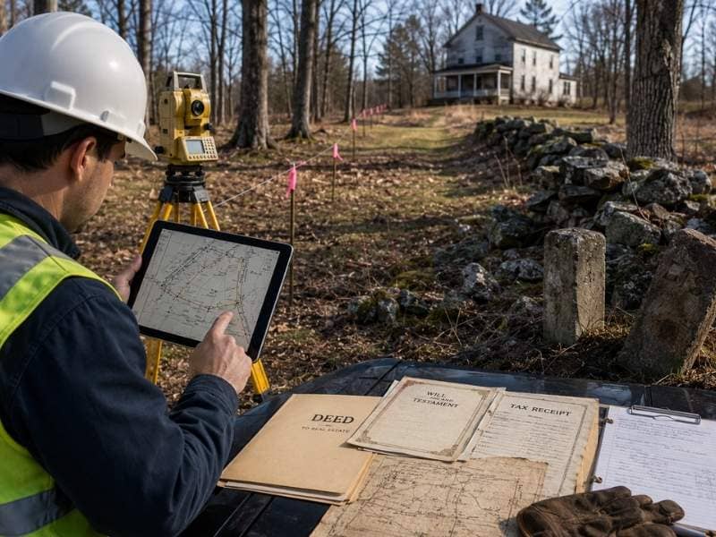
Family Land Records That May Hold Helpful Details
Inherited land comes with its own set of papers, and some of them are more useful than owners think. Wills and estate papers can describe the land in ways that help a surveyor understand how it was divided over the years. Probate records sometimes mention old surveys or describe boundary lines in enough detail to narrow things down. Old tax receipts may list lot sizes that match earlier survey data.
These papers are not the same as recorded deeds and maps, but they fill in gaps when official records are hard to find. A surveyor who gets a folder of family land papers before starting the job can spend more time measuring and less time searching. That difference in preparation can cut down the total time a survey takes, which lowers what it costs.
Physical Signs That Help Rebuild Boundary Lines
Older rural land often has physical clues about where the original boundary lines were. Stone piles at corners were used before iron pins became common. Trees with old marks cut into the bark were once used to show where a boundary line ran. Hand-set concrete posts from older surveys sometimes still exist in spots where they were never disturbed.
These things matter because they give a surveyor something to work from when no modern markers are left. A stone pile in the right spot, matched against an old deed description, can help pin down a corner that would otherwise take much more work to find. Owners who know the land well should walk it before scheduling a survey and note anything that looks like it might have been a boundary marker, even if they are not sure what it is.
Why Larger Gaps in Boundary Evidence Can Add Work
Some inherited parcels have a clear paper trail with just a few missing corners. Those surveys move along once the research is done. Others have gaps on top of gaps. The land may have been split between family members without recorded deeds. A part of it may have been sold years ago without updating the original description. Neighboring land may have changed hands several times under descriptions that do not quite line up.
Each gap adds a step. The surveyor has to sort through each informal split, match up conflicting descriptions, and figure out which version of the boundary has the most support. On land with many generations of informal transfers, that takes much more time than a survey on a parcel with one clean owner history. Owners should tell the surveyor about any splits or sales they know about, even informal ones, so the research starts in the right direction.
Preparing Inherited Property Before Scheduling a Survey
A little preparation before calling a surveyor can cut down on research time. The most useful thing an owner can do is collect every paper related to the land in one place. That includes deeds, wills, estate papers, old tax records, and any surveys the family may have kept over the years.
Talking to older relatives before scheduling the survey is also worth doing. A grandparent or elderly neighbor may know where corners were originally set, which lines were ever disputed, or where a fence was moved at some point. That kind of knowledge does not show up in any official record, but it gives a surveyor a starting point that can save hours of research. The more an owner can share about the land’s history, the less time a surveyor spends uncovering it on their own.
Frequently Asked Questions
How can I tell if inherited land has missing corners?
Signs include no visible stakes or iron pins at lot corners, boundary lines that do not match older records, or neighbors who disagree about where the line sits. A surveyor can check whether corners are in place during the research phase.
Are handwritten deeds useful for a survey?
Yes. Older handwritten records often include descriptions, measurements, or mentions of landmarks that help a surveyor understand the boundary. They may not be exact, but they give useful background that official records sometimes do not have.
Can natural changes make property corners harder to find?
Yes. Erosion, tree growth, brush clearing, and years of farming or land use can bury or destroy corner markers. The longer a property has gone without a survey, the more likely that natural changes have hidden what was once visible on the ground.
Will gathering documents ahead of time help the process?
Yes. Deeds, wills, tax records, and prior surveys give a surveyor a starting point before fieldwork begins. Less time spent hunting for background information usually means a smoother and faster survey.
Is it common for inherited property to have unclear boundaries?
Yes. Properties passed down through families over many years often have missing markers, informal splits, and outdated records. Surveyors who work on rural land expect to find these conditions on inherited parcels.