
FEMA Elevation Certificate Questions Homeowners Keep Asking After Heavy Rain Seasons
A heavy rain season changes the questions homeowners ask about flood risk. Streets that never flooded before hold water for days. Yards that seemed fine turn into soggy messes. And suddenly, people who never thought about FEMA elevation certificates start searching for answers. Some of those questions have simple answers. Others require a closer look at the property itself. Either way, understanding the basics helps homeowners figure out what actually applies to their situation.
Why Street Flooding Does Not Automatically Mean a Property Is in a Flood Zone
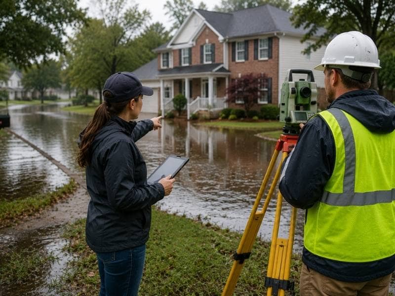
After a wet season, one of the most common concerns homeowners raise is this: water backed up in the street, so does that mean the property is in a flood zone?
Not necessarily. Street flooding and official flood zone designations are two different things.
Street flooding usually happens when storm drains get overwhelmed. Heavy rain falls faster than the drainage system can handle it, water pools temporarily, and then it drains away over hours or days. That kind of flooding is a local drainage issue, not a FEMA designation.
A FEMA flood zone is something different. It’s an official classification based on long-term flood risk modeling for a specific area. FEMA assigns flood zones to land based on how likely that land is to flood in any given year. A property in a high-risk flood zone has a statistically significant chance of flooding regardless of whether the street drains poorly or not.
Seeing water in the street after a storm is worth paying attention to. But it doesn’t automatically mean the property carries the insurance requirements or risk profile that come with an official flood zone designation.
How to Find Out What Flood Zone a Property Is In
Homeowners don’t need to order a survey to find out what flood zone their property sits in. FEMA makes that information available for free through the Flood Map Service Center at msc.fema.gov.
The Flood Map Service Center lets anyone search by address and view the official flood map for that location. Each map covers a specific area identified by a panel number. The map uses letter designations to show flood risk:
- Zone X means the area has a low to moderate flood risk. Most properties in Zone X are not required to carry flood insurance.
- Zone A means the area has a high flood risk. Properties here typically face flood insurance requirements tied to lenders and loans.
- Zone AE is similar to Zone A but includes specific Base Flood Elevation data that shows how high floodwaters are expected to reach.
Reading a flood map for the first time can feel confusing. The colors and lines don’t always make the risk obvious. But knowing which zone a property sits in is the right starting point before asking any further questions about certificates or insurance.
What the Difference Is Between a Flood Map and an Elevation Certificate
Many homeowners assume that if they know their flood zone, they know everything they need to know about their flood risk. That’s not quite right.
A flood map tells you which zone the land falls in. It doesn’t tell you how high a specific house sits relative to the expected flood level.
That’s what an elevation certificate does. It takes the flood zone information from the map and adds a critical detail: the actual elevation of the structure’s lowest floor compared to the Base Flood Elevation for that zone.
Think of it this way. Two houses can sit in the same flood zone on the same street and still face very different levels of risk. One might have been built with the floor sitting two feet above the Base Flood Elevation. The other might sit right at it, or even slightly below. The flood map doesn’t show that difference. The elevation certificate does.
That distinction matters because it affects how insurance companies calculate premiums, how lenders evaluate risk, and whether a homeowner might qualify for lower rates based on their specific structure’s elevation.
Why Two Houses on the Same Street Can Have Very Different Insurance Costs
After a wet season, homeowners sometimes compare flood insurance costs with neighbors and find a surprising gap. One house pays significantly more than another, even though they’re on the same block in the same flood zone.
The difference usually comes down to elevation.
Flood insurance premiums through the National Flood Insurance Program are heavily influenced by how a structure’s lowest floor elevation compares to the Base Flood Elevation. A home that sits two feet above the Base Flood Elevation carries a much lower risk than one sitting at or below it. That difference in risk translates directly into a difference in annual premium, sometimes by hundreds or even thousands of dollars per year.
Without an elevation certificate, insurers have no way to confirm where a specific structure sits relative to the flood reference level. In some cases, they assign a default rate that doesn’t reflect the actual elevation of the home. For homeowners who sit well above the Base Flood Elevation, that default rate can mean paying more than their actual risk warrants.
That’s one reason some homeowners decide to get an elevation certificate even when nobody has required one. It gives the insurer accurate information to work with and may result in a lower premium.
What to Gather Before Talking to a Surveyor About Flood Concerns
When a homeowner decides to speak with a licensed surveyor about flood concerns after a wet season, coming prepared makes the conversation more useful.
A few things worth gathering before that conversation:
- Any existing elevation certificate. If the property has one, even an old one, bring it. The surveyor can review it and advise on whether it still applies.
- The flood insurance declarations page. This shows the current coverage, the flood zone listed on the policy, and the rate being charged. It helps the surveyor understand what’s currently in place.
- The flood map panel number for the property. This can be found through the FEMA Flood Map Service Center. Knowing the panel number and zone designation gives the surveyor a useful starting point.
- Information about any recent structural changes. If the home has been raised, had a room added below the main floor, or gone through any significant renovation since the last certificate was prepared, that information affects whether existing documentation is still accurate.
- Any correspondence from a lender or insurer requesting updated documentation. If a bank or insurance company has asked for a new certificate, bringing that request to the conversation helps the surveyor understand the specific requirement.
Coming prepared with this information means the surveyor can give more specific and useful guidance rather than spending time gathering basic background details.
Frequently Asked Questions
Does street flooding mean my property is in a flood zone?
No. Street flooding usually happens when storm drains get overwhelmed during heavy rain. It’s a drainage issue, not an official FEMA designation. A flood zone is a formal classification based on long-term risk modeling. A property can experience street flooding without being in a high-risk flood zone, and a property in a high-risk zone may not see street flooding at all.
How do I find out what flood zone my property is in?
FEMA’s Flood Map Service Center at msc.fema.gov lets you search by address and view the official flood map for your area at no cost. The map uses zone designations like X, A, and AE to show risk levels. Zone X indicates lower risk. Zones A and AE indicate higher risk with flood insurance implications.
What is the difference between a flood map and an elevation certificate?
A flood map shows which zone a property falls in based on area-wide risk modeling. An elevation certificate shows the actual elevation of a specific structure’s lowest floor compared to the Base Flood Elevation for that zone. The map tells you the zone. The certificate tells you how the building sits within that zone.
What should I bring when I talk to a surveyor about flood concerns?
Bring any existing elevation certificate, your flood insurance declarations page, the flood map panel number for the property, information about any recent structural changes, and any written requests from a lender or insurer asking for updated documentation. That information gives the surveyor what they need to answer your questions accurately.