
LiDAR Mapping Explained: What It Is, How It Works, and Why It Matters for Your Property
You’ve probably heard the term “LiDAR mapping” come up somewhere recently. Maybe a contractor used it. Maybe you caught it in a news story about drones or self-driving cars. Either way, you probably nodded and kept moving without really understanding what it meant.
Most property owners are in the same spot. And that’s worth fixing, because there’s a real chance your land has already been scanned by LiDAR mapping technology without you knowing it.
What Is LiDAR Mapping?
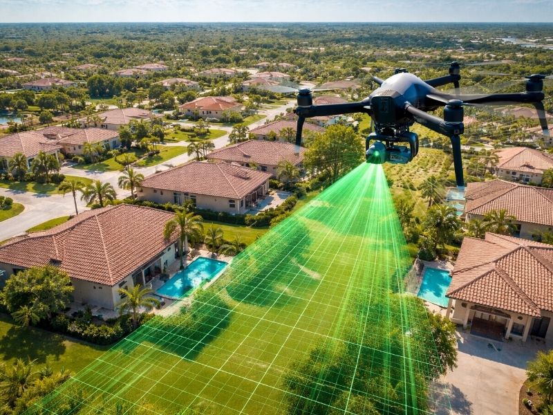
LiDAR mapping is a method of measuring land using rapid laser pulses fired from an aircraft or drone. The system records how long each pulse takes to return, then builds a precise 3D map of the terrain below. It captures millions of measurements per second across large areas.
A sensor fires laser pulses toward the ground, measures the return time of each one, and uses that data to calculate exact distances. Do that millions of times per second and you get something called a point cloud: a dense cluster of 3D data points, each representing a spot the laser touched.
A good way to picture it: think of a bat using echolocation to navigate a dark cave. The bat sends out a sound signal, listens for the echo, and builds a mental map of the space around it. LiDAR works on the same principle, but with light instead of sound, and from a thousand feet in the air instead of a cave ceiling.
The resulting map is far more detailed than anything a standard aerial photo can produce. A camera captures what something looks like. LiDAR captures exactly where everything sits in three-dimensional space.
How Is LiDAR Data Collected?
LiDAR data is collected by mounting a laser sensor on an aircraft, drone, or ground-based tripod. Airborne systems cover large areas quickly. Drone-mounted sensors work better for smaller or wooded sites. Ground-based scanners capture close-range structural detail. Each method produces point cloud data processed into elevation maps.
LiDAR sensors travel. They don’t work from a fixed point. The collection method depends on the size and type of the area being mapped.
Airborne LiDAR is the most common choice for land surveying. A plane flies a programmed route while the sensor fires downward pulses continuously. A single flight can cover hundreds of acres in under an hour. This is how federal agencies like USGS survey entire counties for flood mapping and infrastructure planning.
Drone LiDAR works better for smaller parcels or properties with heavy tree cover. Drones fly lower and slower, which produces finer detail. If your lot is wooded or irregular, a drone survey will capture the terrain more accurately than a plane flying at altitude.
Ground-based LiDAR uses a tripod-mounted scanner that rotates 360 degrees to capture everything around it. Surveyors use this method for buildings, retaining walls, or any site where a flying platform isn’t practical.
All three methods produce the same core output: a dense cloud of elevation measurements ready for processing.
What Does LiDAR Data Produce?
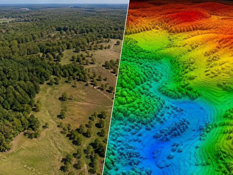
LiDAR processing produces point clouds, Digital Terrain Models (DTMs), Digital Surface Models (DSMs), and contour maps. DTMs show bare-earth elevation. DSMs include all surface features like trees and buildings. These outputs support flood analysis, drainage design, site grading, and elevation certificates.
Raw point cloud data needs processing before it’s useful. Surveyors run the data through software that separates and organizes the millions of return points into meaningful products.
A DTM (Digital Terrain Model) filters out everything sitting on top of the ground. Buildings, trees, power lines, and fences get removed, leaving only the bare earth surface. This is the output surveyors use for flood analysis, drainage planning, and cut-and-fill calculations on a site.
A DSM (Digital Surface Model) keeps everything in. The ground, every structure, every tree. It’s useful for construction planning and assessing how vegetation affects a site.
From either model, surveyors can generate contour maps showing how elevation changes across a property, predict where water will flow during heavy rain, and calculate how much soil needs to move before construction begins.
For homeowners specifically, the most relevant output is often a precise elevation reading tied directly to flood risk.
How Does LiDAR Compare to a Traditional Land Survey?
Traditional surveys establish legal property boundaries with high precision. LiDAR collects terrain elevation data across large areas faster than ground crews can. The two methods work together: LiDAR handles broad terrain capture while a licensed surveyor interprets, certifies, and applies the data to legal standards.
Traditional surveying isn’t going anywhere. A licensed surveyor walking a property with a GPS unit or total station can establish legal boundary lines with a level of precision that LiDAR alone can’t provide. Courts, lenders, and title companies still require that certified human judgment.
But LiDAR handles things a ground crew simply can’t.
Dense tree canopy that blocks GPS signals? LiDAR pulses slip through gaps in the leaves and still reach the ground. A 40-acre wooded tract that would take a crew several days to measure by hand? A drone maps it in one afternoon. Subtle elevation shifts of just a few inches across a wide, flat lot? LiDAR catches them consistently where traditional measurements might not.
The two approaches complement each other. LiDAR captures the terrain fast and at scale. The licensed surveyor interprets that data, applies the legal framework, and puts their stamp on the result.
How Does LiDAR Affect Your Property and Flood Insurance?
FEMA uses LiDAR elevation data under its Risk Rating 2.0 system to estimate each property’s flood risk and set insurance premiums automatically. If FEMA’s LiDAR estimate is lower than your home’s actual elevation, you may be overpaying. A licensed surveyor can produce an Elevation Certificate to correct that figure and potentially reduce your premium.
This is where LiDAR stops being a technical topic and starts affecting your wallet.
FEMA now prices flood insurance premiums using automated LiDAR elevation estimates. When your policy renews, your insurer quotes a rate based partly on a calculated figure for how high your home sits above the base flood elevation. That figure comes from LiDAR data collected by aircraft, processed algorithmically, and applied to your specific address.
The problem is that those automated estimates aren’t always accurate. Older homes, properties with raised foundations, and structures with steps up to the entry door often get assigned a lower elevation than they actually have. When FEMA underestimates your elevation, your premium goes up.
A licensed land surveyor can physically measure your home’s true elevation and document it in an official Elevation Certificate. If that measured elevation is higher than FEMA’s automated figure, submitting the certificate to your insurer can lower your annual premium. In many cases, the savings are several hundred dollars per year, and the certificate pays for itself within one or two policy cycles.
The same logic applies when buying land near a drainage area, creek, or low-lying corridor. A LiDAR-based topographic survey shows exactly how water moves across that lot before you build. Getting that picture early is far cheaper than correcting a drainage problem after a foundation is poured.
When Should You Request a LiDAR Survey?
Request a LiDAR survey when buying wooded or rural land, planning construction near a flood zone, challenging a flood insurance rate, developing a subdivision, or applying for a building permit requiring a topographic map. A licensed surveyor can review existing public LiDAR data first to determine whether a new survey is necessary.
Not every property needs a fresh LiDAR survey. A simple boundary survey on a flat suburban lot usually doesn’t call for one.
But a conversation with your surveyor about LiDAR is worth having if any of the following apply:
- Your property sits in or near a mapped flood zone
- You want to challenge your current flood insurance premium
- You’re buying wooded, rural, or large-acreage land
- You plan to build, grade, add drainage, or pave
- You’re subdividing or developing a tract
- You need a topographic map for a permit application
In most parts of the country, public LiDAR data for your parcel already exists. Your surveyor can pull it, review its age and resolution, and tell you whether it holds up for your specific purpose or whether a new survey is the smarter move.
The data is out there. The real question is whether it’s accurate enough to protect you.