
Elevation Certificate: Why Older Homes Sometimes Need New Measurements
Many homeowners have an elevation certificate from years ago and think it still works. Sometimes it does. But old information can quietly raise flood insurance costs, slow down a refinance, or cause problems when selling a home. Knowing when a new one is needed can prevent delays and save money.
What Is an Elevation Certificate?
An elevation certificate is an official document that shows how high a home sits compared to a number called the Base Flood Elevation. FEMA, the federal agency that helps communities prepare for disasters, sets that number. It represents how high floodwater could rise during a major flood in a given area.
Insurance companies and lenders use this document to decide how much flood risk a property has. The higher a home sits above the Base Flood Elevation, the lower the risk. Lower risk usually means lower flood insurance costs.
How FEMA Map Updates Can Make a Certificate Outdated
FEMA updates its flood maps regularly. When a map is revised, the Base Flood Elevation for certain areas can change. That matters because every elevation certificate is tied to the flood map that was in use when the survey was done.
If the map has been updated since the certificate was prepared, the document may no longer show the correct flood zone data for that property. The measurements in the certificate might still be accurate, but they are being compared against old information. Lenders and insurers typically require documents that match the current map.
FEMA publishes official notices when map changes take effect. If a property’s flood zone changed after the original certificate was issued, getting new measurements is usually the simplest way to fix the record.
How Home Improvements Can Affect a Certificate
An elevation certificate reflects what a property looked like on the day the survey was done. If the structure changed after that date, the document no longer tells the full story.
Raising a home is the clearest example. Some homeowners in flood-prone areas lift their homes onto taller foundations to reduce flood risk. That work changes the lowest floor elevation, which is one of the key numbers on the certificate. If the old document still shows the pre-lift number, the insurer is working with wrong information.
Adding enclosed space below the main floor creates the same problem. A new garage, storage area, or finished crawl space that was not part of the original survey can change how a property is rated for flood insurance. Big renovations that require permits may also lead to a review of the existing certificate, depending on what was changed.
How Elevation Data Affects Insurance Costs
Flood insurance through the National Flood Insurance Program is priced based on how close a home’s lowest floor is to the Base Flood Elevation for its flood zone. The smaller that gap, the higher the risk and, in most cases, the higher the premium.
An outdated certificate can push costs in the wrong direction. If a homeowner raised their home but never updated the certificate, the insurer is still using the old, lower floor number. That can mean paying more than the current condition of the property actually calls for.
The reverse situation also causes problems. If the Base Flood Elevation in an area went up because of a map revision and the certificate has not been updated, the numbers used to calculate the premium may not be accurate. Current elevation data keeps the insurance cost tied to the real picture.
When a New Certificate May Be Required
Several common situations can lead to a request for an updated certificate, even when the existing one looks fine.
Refinancing is one of the most common triggers. Lenders reviewing a loan on a property in a high-risk flood zone usually require current elevation documents as part of the review process. A certificate from many years ago may not meet their requirements, especially if the flood map has been revised since it was prepared.
Selling a home can create the same situation. A buyer’s lender may flag a certificate that is too old or note that the home was changed after the survey. Sorting that out before closing is much easier than dealing with it during the sale.
Local permit offices also ask for current elevation data when homeowners apply for building permits in flood-prone areas. Many cities and counties require up-to-date documents before approving major construction or renovation work, no matter when the original certificate was prepared.
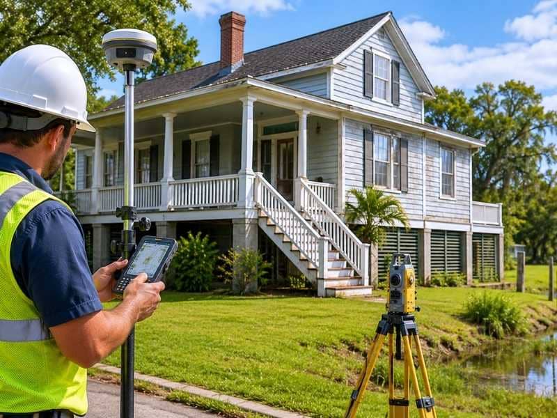
What the Process Involves
Getting an elevation certificate means a licensed professional visits the property and takes specific measurements. The surveyor records the elevation of the lowest floor, notes the type of foundation, checks any openings in below-ground areas, and looks up the current FEMA flood map for that location.
All of that information goes onto a standard FEMA form used across the country. Once the work is done, the professional signs and seals the document. Only licensed land surveyors and certain engineers approved by FEMA can prepare elevation certificates. General contractors and home inspectors do not qualify.
Most site visits take a few hours. The finished certificate is usually ready within a few days after the visit, though timing depends on the surveyor’s schedule and the details of the property.
Frequently Asked Questions
Does an elevation certificate expire?
There is no set expiration date. A certificate becomes outdated when flood maps are revised, the home is structurally changed, or a lender or insurer asks for documents tied to the current map.
Can home improvements affect an elevation certificate?
Yes. Raising the home, enclosing areas below the main floor, or making major foundation changes can all alter the elevation data. A new certificate shows the current condition of the property.
Who can prepare an elevation certificate?
Licensed land surveyors and certain engineers approved by FEMA can prepare elevation certificates. The completed form must be signed and sealed by a qualified professional.
Will a new elevation certificate lower flood insurance costs?
It can. If new measurements show the home sits higher above the Base Flood Elevation than the old certificate indicated, the insurer may offer a lower rate. The result depends on the actual numbers.
How long does it take to get one?
Most certificates are ready within a few days after the surveyor’s visit. Timing depends on the surveyor’s schedule and the details of the property.