
Land Survey Cost: Why Two Similar Properties Can Receive Very Different Quotes
Two properties can sit side by side, have the same acreage, and still receive very different survey quotes. That’s because land survey cost depends on much more than property size. Research requirements, site conditions, survey type, and local regulations all affect the amount of work involved.
If two neighbors on the same street get land survey quotes and one pays $800 while the other pays $2,500, that’s not a billing error. Land survey cost varies widely, even between properties that look nearly identical. Most people assume acreage is the main driver. It’s one factor, but several others carry just as much weight. Understanding what goes into a survey quote helps set realistic expectations before any project begins.
Why Property Size Alone Doesn’t Determine Land Survey Cost
Land survey cost is based on time and effort, not square footage alone. Two properties with the same acreage can require very different amounts of research, fieldwork, and documentation, which is why quotes between similar lots can differ by hundreds or even thousands of dollars.
A five-acre parcel with clean records, clearly set monuments, and easy vehicle access might take a crew half a day. Another five-acre parcel with no prior survey history, disputed boundary lines, and a drainage channel cutting through the back corner could take two full days. Same size on paper. Very different workload on the ground.
Surveyors price jobs based on what they actually require. Acreage is a starting point, not a final answer.
How Existing Records and Boundary Evidence Influence Pricing
Before a crew arrives on site, a surveyor spends time at the desk pulling deeds, plats, prior surveys, and county records to piece together the legal history of the parcel. How long that takes depends entirely on what’s available.
A property with a recently recorded plat and original monuments still in the ground is straightforward to research. Contrast that with an older rural parcel originally described using trees and fence posts that no longer exist, or with records scattered across multiple county offices. That kind of research can stretch from a few hours into several days.
Poor records don’t just add time. A surveyor working through conflicting legal descriptions has to determine which one controls and document the reasoning. That professional judgment is part of what shows up in the quote.
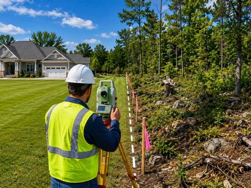
How Terrain, Vegetation, and Site Conditions Drive Up Survey Costs
This is the factor that surprises most property owners.
Clear, flat, open ground is fast to survey. A wooded lot with thick brush is not. Survey equipment needs clear sightlines between measurement points, and dense vegetation blocks those sightlines. A heavily wooded lot of the same size as an open one can take two to three times longer to complete.
Steep slopes require more instrument setups to cover the same distance accurately. Wet or marshy areas may force the crew to adjust their approach. Locked gates, restricted access, or a neighbor who won’t allow crew members near a shared fence line all add time before any measurements get recorded.
Site conditions don’t appear in a property description. Most surveyors ask about them before generating a quote, and a quote based only on address and acreage may change once the crew sees the property in person.
Why the Type of Survey Requested Changes the Final Quote
Not all surveys are the same job, and they don’t carry the same price.
A boundary survey locates and documents the property lines. It’s the most common type for residential lots and tends to be the most affordable.
A topographic survey maps the physical features of the land, including grades, elevation changes, drainage patterns, and existing structures. Architects and engineers typically require one before designing a project. It involves more fieldwork than a standard boundary survey.
An ALTA/NSPS Land Title Survey follows national minimum standards set jointly by the American Land Title Association and the National Society of Professional Surveyors. These surveys are standard in commercial real estate transactions and require stricter documentation and significantly more research. Commercial ALTA surveys typically range from $2,000 to $8,000 or more, depending on site size and complexity.
Construction staking is a separate service where the crew places physical stakes in the ground to guide grading, foundation work, or utility installation. The cost depends on how many points need to be staked and the scale of the project.
Asking for “a survey” without specifying the type is like asking a contractor for “some work.” The scope defines the price.
How Local Regulations and Project Requirements Add to the Cost
Sometimes the cost goes up before the crew ever leaves the office, and the property itself has nothing to do with it.
Some municipalities require surveys submitted in specific formats, tied to local benchmarks, or reviewed by a third party before permits are issued. Subdivision work often requires recorded plats or planning board approvals that add time and cost to the process.
Client-specific requests add scope too. A lender may require specific certification language. A developer may need a legal description rewritten. An attorney handling a dispute may request a detailed exhibit map. None of these are unusual, but each one adds to the total hours.
The more clearly a property owner explains what the survey is for, the more accurate the initial quote will be.
Frequently Asked Questions
What factors affect land survey cost?
Property size, terrain, site accessibility, available records, and the type of survey all influence the price. No single factor determines the final number on its own.
Why can two similar properties have different survey prices?
Properties that look alike on paper may require very different amounts of research, fieldwork, and documentation once a surveyor works through the details.
Does a larger property always cost more to survey?
No. A small property with complex boundaries, difficult terrain, or poor record history can cost more than a larger, straightforward parcel.
Does thick vegetation increase land survey cost?
Yes. Dense trees and brush slow fieldwork by blocking equipment sightlines. A heavily wooded lot can take two to three times longer to survey than a clear one of the same size.
Are ALTA surveys more expensive than boundary surveys?
Generally, yes. ALTA/NSPS surveys follow stricter national standards, require more detailed research and documentation, and typically cost more than a standard residential boundary survey. Commercial ALTA surveys commonly range from $2,000 to $8,000 or more.
Can existing survey records reduce the cost?
They can reduce research time, but they don’t replace the need for new fieldwork. Conditions on the ground still need to be physically verified.
How can I get an accurate land survey quote?
Provide the property address, a copy of the legal description, and a clear explanation of what the survey is needed for. More detail up front allows the surveyor to give a more accurate estimate.